


2021-10-11_06h42m38_Lac La Thuile-G3

papou73
User
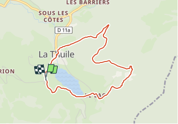

Length
4.3 km

Max alt
1063 m

Uphill gradient
198 m
Km-Effort
7 km

Min alt
879 m

Downhill gradient
198 m
Boucle
Yes
Creation date :
2021-10-11 04:42:38.883
Updated on :
2021-10-11 04:46:01.689

FREE GPS app for hiking
 SityTrail
IGN / Geographical institutes
SityTrail Plus
The world is yours!
About
Trail of 4.3 km to be discovered at Auvergne-Rhône-Alpes, Savoy, La Thuile. This trail is proposed by papou73.
Positioning
Country:
France
Region :
Auvergne-Rhône-Alpes
Department/Province :
Savoy
Municipality :
La Thuile
Location:
Unknown
Start:(Dec)
Start:(UTM)
269892 ; 5046071 (32T) N.
Comments